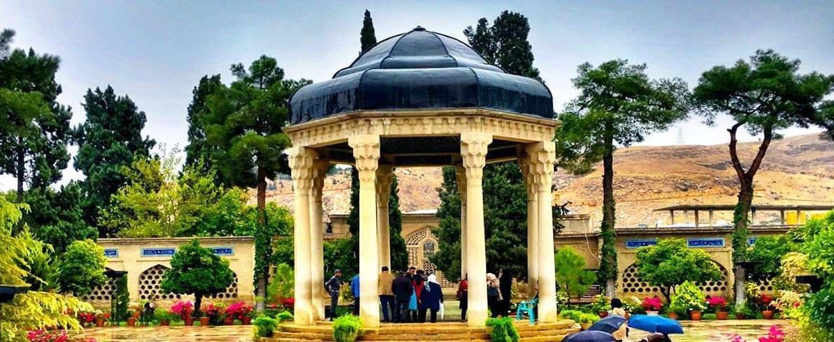
Naqsh-e Jahan Square

By Mr.Ashayeri (JSI2370)
Naqsh-e Jahan Square , also known as the Shah Square prior to 1979, is a square situated at the center of Isfahan, Iran. Constructed between 1598 and 1629, it is now an important historical site, and one of UNESCO’s World Heritage Sites. It is 160 metres (520 ft) wide by 560 metres (1,840 ft) long(an area of 89,600 square metres (964,000 sq ft)). It is also referred to as Shah Square or Imam Square.The square is surrounded by buildings from the Safavid era. The Shah Mosque is situated on the south side of this square. On the west side is the Ali Qapu Palace. Sheikh Lotf Allah Mosque is situated on the eastern side of this square and at the northern side Qeysarie Gate opens into the Isfahan Grand Bazaar. Today, Namaaz-e Jom’eh (the Muslim Friday prayer) is held in the Shah Mosque.
The square is depicted on the reverse of the Iranian 20,000 rials banknote.Stores are owned by trust of Ostandari Isfahan.

Masal
By Mr.Ashayeri (JSI2364)
Masal is a city in Gilan province of Iran, which is located next to Talash mountains. The people of this city speak Talshi language. This city is located in the clouds most days of the year, that’s why it was nicknamed “the lost paradise of Gilan”.
Khalkai River
The city of Masal has many big and small rivers and streams, this city is located next to the great river Khalkai, which originates from the high peak of Shah Molem Masal, after 40 kilometers it passes through the city of Masal and flows into the Caspian Sea.


Kandovan

By Mr.Ashayeri (JSI2363)
Kandovan is an ancient village in Sahand Rural District in the Central District of Osku County, East Azerbaijan Province, northwestern Iran. It is situated in the foothills of Mount Sahand, near the city of Osku. At the 2006 census, the village population was 601, in 168 families.
The village exemplifies manmade cliff dwellings which are still inhabited. The troglodyte homes, excavated inside volcanic rocks similar to dwellings in the Turkish region of Cappadocia, are locally called Karaan.Karaans were cut into non-welded ignimbrites, also called “ash-flow tuffs,” of Mount Sahand. The cone form of the houses is the result of the erosion of ignimbrite layers consisting of porous, round and angular pumice together with other volcanic particles that were positioned in a grey, acidic matrix. During the eruption of Sahand, pyroclastic flows formed the rocks of Kandovan. Around the village the thickness of this formation exceeds 100 metres (330 ft) and with time, due to water erosion, the cone-shaped cliffs were formed.

